“For this political diversity Europe had largely to thank its geography. There were no enormous plains over which an empire of horsemen cold impose its swift dominion; nor were there any broad and fertile river zones like those around the Ganges, Nile,Tigris and Euphrates, Yellow, and Yangtze, providing food for masses of toiling and easily conquerable peasants. Europe’s landscape was much more fractured, with mountain ranges and large forest separating the scattered population centers in the valleys; and its climate altered considerably from north to south and west to east. This had a number of important consequences. For a start, it both made difficult the establishment of unified control, even by a powerful and determined warlord, and minimized the possibility that the continent could be overrun by an external force like the Mongol hordes.
Conversely, this variegated landscape encouraged the growth, and the continued existence, of decentralized power, with local kingdoms and marcher lordships and highland clans and lowland town confederations making a political map of Europe drawn at any time after the fall of Rome lool like a patchwork quilt. The patterns on that quilt might vary from century to century, but no single color could ever be used to denote a unified empire.
Europe’s differentiated climate led to differentiated products, suitable for exchange; and in time, as market relations developed, they were transported along the rivers or the pathways which cut through the forests between one area of settlement and the next. Probably the most important characteristic of this commerce was that it consisted primarily of bulk products timber, grain, wine, wool, herrings, and so on catering to the rising population of the fifteenth century Europe, rather than the luxuries carried on the oriental caravans. Here again geography played a crucial role, for water transport of these goods was so much more economical and Europe possessed many navigable rivers. Being surrounded by seas was a further incentive to the vital ship building industry, and the later Middle Ages a flourishing maritime commerce was being carried out between the Baltic, the North Sea, the Mediterranean and the Black Sea.” [1]
And here is Mr. Diamond’s version of the same thesis:
“China’s frequent unity and Europe’s perpetual disunity both have a long history. The most productive areas of modern China were politically joined for the first time in 221 BC and have remained so for most of the time since then. China has had a single writing system from the beginnings of literacy, a single dominant language for a long time, and substantial cultural unity for 2,000 years. In contrast, Europe has never come close to political unification. Still splintered into 1,000 independent statelets in the 14th century, into 500 statelets in 1500, reduced to a minimum of 25 states in the 1980s, these have increased again to nearly 40 at the time of writing. Europe still has 45 languages, and even greater cultural diversity. The disagreements that continue to frustrate even modest attempts at European unification through the EU are symptomatic of Europe’s ingrained commitment to disunity.
Map of the coastlines of China and Europe,
drawn to the same scale.
Source: Jared Diamond,
Guns, Germs and Steel, p. 415.To understand China’s loss of political and technological pre-eminence to Europe we must understand why China has remained united, and Europe fragmented. Maps provide the clue. Europe has a highly indented coastline, with five large peninsulas that are island-like in their isolation, and all of which evolved independent languages, ethnic groups and governments: Greece, Italy, Iberia, Denmark and Norway/Sweden. China’s coastline is much smoother, and only the nearby Korean peninsula attained separate importance. Europe has two islands (Britain and Ireland) large enough to assert their political independence and maintain their own languages and ethnicities. Indeed one is big and close enough to become a major independent European power. China’s two largest islands, Taiwan and Hainan, are each less than half the area of Ireland; neither was an independent power until Taiwan’s emergence in recent decades. Japan’s geographic distance from the Asian mainland kept it much more isolated politically than Britain has been from main-land Europe. Europe is carved up into independent linguistic, ethnic and political units by high mountains (the Alps, Pyrenees, Carpathians and Norwegian border mountains), while China’s mountains east of the Tibetan plateau are less formidable barriers. China’s heartland is bound together by two long navigable river systems in rich alluvial valleys (the Yangtze and Yellow rivers), and it is joined from north to south by relatively easy con-nections between these two river systems. As a result, China very early became dominated by two huge geographic core areas of high productivity, which gradually fused into one. Europe’s two biggest rivers, the Rhine and Danube, are shorter and connect less of Europe. Unlike China, Europe has many scattered “core” areas, none big enough to dominate the others for long, and each the centre of an independent state.” [2]

Both historians contend that Europe’s fractured physical geography led to its fractured political divisions, and that the lack of such clear geographic divisions explains China’s political unity. For simplicity’s sake let us call this the “Fractured Lands Hypothesis.“
I once found this hypothesis very convincing. Then I began to study Chinese history. The more I learn about China’s past the less convincing this argument is. A few of its serious problems are outlined below.
NOTE: While preparing materials for this post I came across Peter Turchin’s note “Why Europe is Not China.” I was surprised to find that he agrees with my assessment and makes many of the same points I planned to make in here using the same historical examples I intended to use! (Up to an including the reference to the film Red Cliff.) There is no need to reproduce his material here so please read his post before continuing on with this one.
The Fractured Land Hypothesis’ explanation of Chinese unity fails on two counts:
#1 – China’s geography is not homogenous – it is just as fractured as the rest of the world.
The idea that China’s geography is unhindered by major geographic, topographic, or ecological barriers is faulty. It is often based on maps like the one used by Jared Diamond above. The map cleverly conceals China’s geographic diversity by only distinguishing the land from the sea. All of China is depicted in homogenous white. Alas, there is more to a continent than its coast line. A different picture emerges when we look at China from a topographic perspective:
On the basis of topography alone we can divide Eastern China into several discrete areas: the first is the Central Plain, following along the lower reachers of the Huang, comprising modern Southern Shanxi and Hebei, and North Eastern Henan, and Shandong in its entirety. Ancient sources often called this area Guandong (关东), or “East of the Passes.” Directly to its West, over the Taihang Mountains, was Guanzhong (关中), or “Within the Passes,” comprising parts of Western Henan and most of Shaanxi today. The elevation is higher here than in the Central Plain; its population is centered on the Wei River Valley, easily seen on the topographical map above.
During the classical age of China’s history (c. 771 BC-220 AD) these two regions were the major “centers” of the Chinese world. Passage from one center to another was difficult, limited to a few mountain passes. The Hangu Pass was the most important of these; firm control of the pass was a strategic priority for every warlord claiming either region. It has been the site of dozens of battles since antiquity.
 |
|
The Hangu Pass (函谷關), dividing Guanzhong and Guandong. Source: ‘Hovering Month.’ “Hangu Pass Pictures.” Posted on Mafengwo Travel Guides, Henan Travel section. (Chinese language source). |
South of Guanzhong is the Sichuan Basin. 100 million people call the modern states of Sichuan and Chongqing home today; before the state of Qin (c. 800-221 BC) conquered the region its inhabitants were the Ba and Shu peoples. Ringed by mountains, the Sichuan Basin has only a few points of entry: in the North through Hanzhong, and in the East by way of the Yangtze. The Qin conquered Ba and Shu before beginning their rampage across the Central Plain (some have suggested that their conquest of the Sichuan Basin gave them the resource boost they needed to do so ), but over the course of subsequent Chinese history imperial control over the Basin often faltered, with dynasties abandoning the region to indigenous tribes and kingdoms in times of great stress or collapse.
The lower reaches of the Yangtze river form another major region in Eastern China. Like the Central Plain, the Yangtze region is an alluvial plain dominated by the river which runs through it. Partly on the basis of their similar topographic profile, some geographers will throw the Yangtze and Central Plain together in one large “Northern Plain” region. I think this is unwise. The topography of the two regions is similar, but the ecology of each are very different. These differences ultimately derive from climate. The Yangtze basin is both hotter and wetter than the Central Plain; every year twice the amount of rain falls into the lower reaches of Yangtze than falls into the lower reaches of the Huang. The ecological effects of humidity, precipitation, and temperature can be seen in the types of crops farmers are able to grow in each region:

The ancient Chinese certainly considered the two regions distinct. During the Spring and Autumn (771-476 BC) and Warring States (475-221 BC) periods, Chinese literati and statesmen from Guandong believed that men from Chu, Yue, and Wu – all states founded along along the Yangtze plain – were semi-barbarians that were not fully a part the Chinese cultural sphere. Waves of Han immigrants over the centuries would change this perception; by the time of the Song Dynasty (960-1279) China’s capital rested on the banks of the Yangtze.
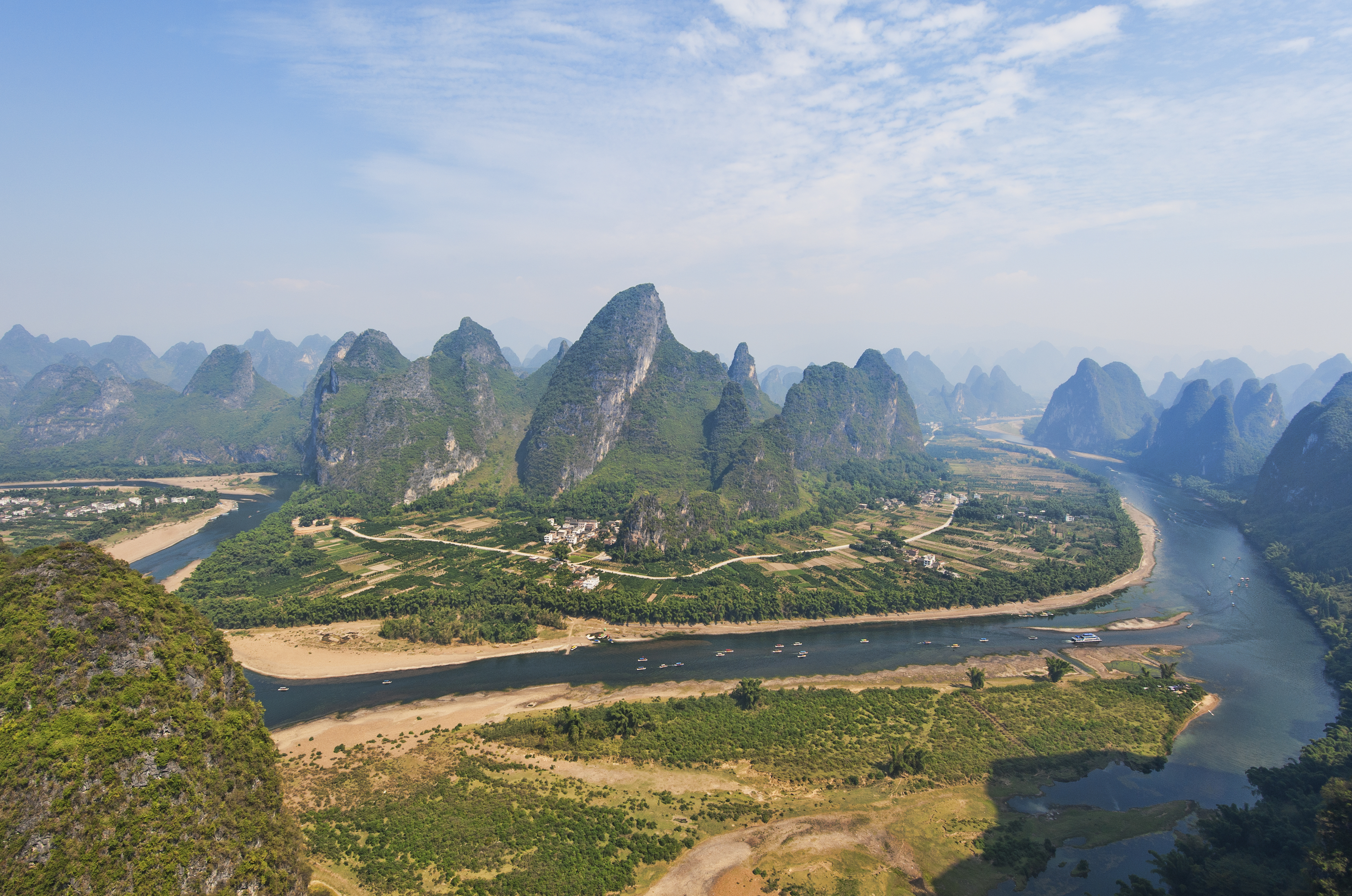 |
| Karst hill country in Guilin, Guangxi. Source: Wikipedia. |

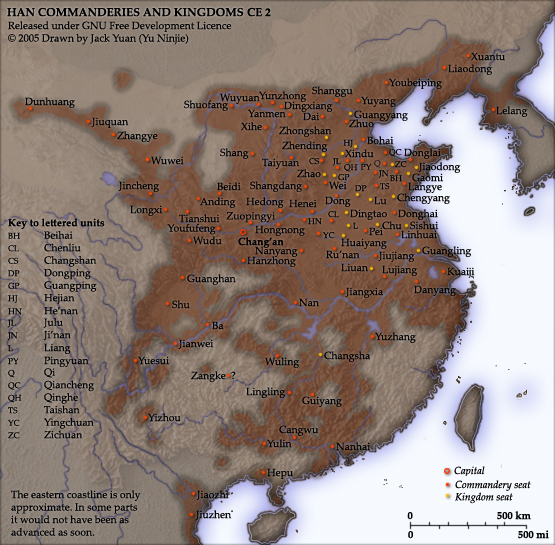
The final region of Eastern China stretches from the Yangtze River Plain in the North to Vietnam in the South. This is the region often called the “Southern Hills” by geographers. Of all the regions of “China proper” the Southern Hills took the longest to incorporate into both the Chinese cultural and political sphere. The early dynasties did not bother trying to conquer most of the region (see this map of the Han Dynasty) and many parts of Guangxi and Guangdong were not incorporated until the Qing Dynasty (1644-1912). Today the more remote parts of Fujian, Zhejiang, Guangdong, and Guanxi still are dotted with ethnic minority villages. As with the Basques of the Iberian Peninsula, the region’s rough geography allowed ethnic minorities to persist in large numbers despite deliberate Sinicization efforts on the part of the Chinese state.
This brings us to the second point.
#2 – China has often been fractured politically along geographic lines.
“The empire, long divided, must unite; long united, must divide. Thus it has ever been.” So begins Luo Guanzhong’s famous historical epic Three Kingdoms. One of China’s “Four Great Classical Novels,” the stories contained inside are some of the most beloved and well known of the entire East Asian intellectual tradition. It both influenced and captured Chinese attitudes towards their history as the inevitable cycle between dynasty and disarray.
Luo Guanzhong had the benefit of hindsight. He wrote during the early Ming Dynasty (1388-1664), when China was strong and unified. He knew that China would unite once again. The historical characters whose adventures he embellished did not have this foresight. They were the first to live through an imperial collapse. By the time the disunity of the”Six Dynasties” ended Chinese civilization had passed more years divided than united!
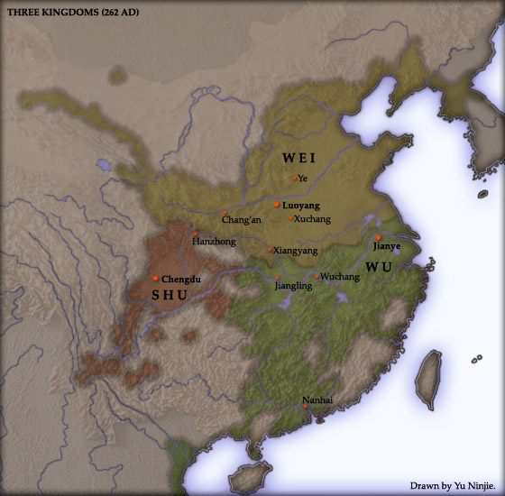
China’s fractured geography played a major role in China’s periods of political disunity. The Three Kingdoms Luo Guanzhong wrote about are a case in point. With the collapse of the Han Dynasty the three warlords who arose from the wreckage built their kingdoms around the basic geographic barriers of East China. Liu Bei, leader of the kingdom of Shu, made the Sichuan Basin the center of his operations; the Sun clan claimed the kingdom of Wu, protected by the Yangtze, and Guanzhong and Guandong were captured by the brilliant maneuvers of Cao Cao, founder of the Wei kingdom. Despite his brilliance, Cao Cao had to give up his hopes of universal domination when the fleet he pulled together to invade Wu was burned by fireships at the Battle of Red Cliffs. Without his fleet he had no way to get at his enemies; the mountains of Sichuan and the waters of the Yangtze were barriers too large for the conquerer to overcome.
 |
|
The Three Kingdoms of storied fame. Source: Wikimedia. |
Rivers would prove the end of many conquerers. Cao Cao was defeated on the banks of the Yangtze; the Southern Song Dynasty made their stand against the Liao, Jin, and Mongols on the banks of the much smaller Huai:
 |
|
The Song Dynasty (Green) retreated behind the Huai River when nomads from Manchuria overwhelmed their forces on the Central Plain. Image Source: GeoNova. “Song and Jin Dynasties.” mapshop.com. Accessed 29 April 2013. |
Mountain ranges also played their part. The much contested Hangu Pass has already been mentioned; the hills and mountains of South China were no less important, ensuring that the region took millennia to conquer and incorporate. The ecological gap between the North and South only made the task harder. A great deal of historical research has shown the difficulty migrant and conquering people have establishing themselves or stamping out local cultures in lands ecologically different than their own [5]; the Chinese of the Northern plain found the challenge no easier than the rest of humanity. The numerous Chinese dialects of the Southern Hills region suggests how limited this “universal” cultural assimilation really was.
 |
|
A map of Sinitic languages in China – notice that most are South of the Yangtze. Source: Wikimedia. |
All of these things present serious problems with the Fractured Land Hypothesis. A close examination of the geography of East Asia suggests that there is no geographic feature capable of explaining the divergent paths of European powers like Germany, France, and the Netherlands that cannot be found in China. Chinese unity did not come because of its geography. It came in spite of it.
———————–
[5] By far the best (and entertaining) introduction to this research is Alfred Crosby. Ecological Imperialism: The Biological Expansion of Europe, 900-1900. (Cambridge: Cambridge University press). 1992.